 |
 |
Place Names(Cities, Towns, Lost Towns, Places) |
|
|
|
Place Names(Cities, Towns, Lost Towns, Places) |
|
Codes: F - Ferry Crossing |
I - Island |
| Place Name | Code | Township | Est. | Post Offices | T/R/S | Latitude | Longitude | Comments |
| Aalberg | L | Rockford | T54R21S28 | on the Burlington & Northern railroad, south of Highway A | ||||
| Alderton | L | Sugar Tree | 1843 | T51R23S16 | a proposed city in the northwest quarter of Setion 16; plat was filed February 3, 1843, by J. t. Kelly and Paul Alder, who were the promoters of the enterprise
no permanent improvements were made on this site, which was subsequently washed into the Missouri River, the original town site having been only 201 rods [3115 feet] from the river bank |
|||
| Ameryville | L | 1879-1883 | "lost city"; no longer exists | |||||
| Asper | L | Stokes Mound | 1880-1903 | T55R23S04 | 39.6055 | -93.4777 | on the north line of the county, in the northeast quart of Section 4
at one time consisted of a general store, a blacksmith shop, and a post office the post office was dissipated and the town was abandoned there was an Asper in Section 17, of Fairview Township, in Livingston County also |
|
| Ault | L | 1885-1892 | "lost city"; no longer exists | |||||
| Baileyville | L | Fairfield | 1856 | T54R25S21 | Located 18 miles northwest of Carrollton
July 10, 1856, Bailey Elder platted the town Composed of six blocks of six lots each, the lots to be 66 by 90 feet. There never were any improvements made upon this location, with the exception of a few houses |
|||
| Baker's Landing | ||||||||
| Battsville | L | Hurricane (southeast part) | 1872-1873, 1877-1888 | abandoned when the Chicago, Burlington, & Kansas City railroad was built | ||||
| Baum's Mill | L | Combs | 1859 | 1857-1868, 1880 | T52R22S15 | located on Big Creek
for a number of years was the only mill around and did a thriving business. On July 25, 1859, Joseph Smith made a survey and plat of the town of "Millford" for Absolum Taggart, who owned land in the southeast quarter of S15. The town of MIllford was located near the northwest corner of the section, consisting of 17 lots. Only a few of these lots were ever sold and with the exception of the mill and one store, no other improvements were ever made. The town site has been abandoned. |
||
| Beatrice | L | 1885-1888 | ||||||
| Bingham | L | Trotter | 1894-1901 | T53R24S08 | 39.4169 | -93.6210 | A post office was established but was later abandoned after the establishment of rural free delivery | |
| Blandeaus | [see Trading Post of Blandeau and Choteau] | |||||||
| Bloomfield | L | Eugene | 1818 | T52R22S07 | During 1818, the town was laid out in the forks of Wakenda Cree, on the southwest quarter of S7. The town was never established. A store was kept there at one time by Lewis N. Russ. The town was abandoned because many people developed chills and fevers, such as ague and malaria type diseases. | |||
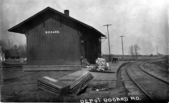
| Bogard | T | Van Horn | 1884 | 1884-present | T54R23
SE1/4 of SW1/4 S30 |
39.4575 | -93.5235 | west on Hwy A, west of Hwy 65
elevation 860 feet August 4, 1884, on petition of H. C. Brasher, the village of Bogard was incorporated the town is located almost in the center of the county. It had one newspaper, a bank, and various businesses |
| Bogard | R | |||||||
| Bogard Mound | L | Leslie | 1872-1884 | T54R24S25 | ||||
| Bogard's Mound | S | 39.47 | -93.54 | Bogard area | ||||
| Boone's Lick | L | now Franklin | ||||||
| Bosworth | Ridge | 1890 | 1888-present | T54R21S26
[?T54R22S23 & 26] |
39.4697 | -93.3346 | at the junction of M & 139
elevation 729 feet population (1899) was about 600 12 miles northeast of Carrollton August 5, 1890, on petition of J. D. Rose and 60+ other men, the town of Bosworth was incorported Laid out and first settled in 1888. It had a public school, Baptist and Methodist Episcopal Churches, a bank, flour mill, saw mill, and handle factory, a newspaper "The Sentinel" and about 30 other businesses, large and small. |
|
| Bowdry | L | Carrollton | 1899-1905 | T52R23S30&31&32 | 39.2822 | -93.5113 | in the southwest section of the county, 6 miles south of Carrollton, on Hwy 65/24, north of the Missouri River | |
| Bower City | L | 1871-1872 | ||||||
| Bradley | L | 1885-1888 | ||||||
| Braymer | ||||||||
| Bridge Creek | L | Hurricane | 1870-1884 | 39.5722 | -93.3846 | located midway between Hale and Tina, 21 miles northeast of Carrollton
one of the first post offices established in Hurricane Township consisted of a post office, dry goods store, drug store, blacksmith shop, one church, and seven residences abandoned when railroad built the Bridge Creek Station about a half mile north of the town |
||
| Buckskin Tavern | L | Leslie | T54R24S07 | located near the center of the north half of S7 about one mile northwest of Mandeville. The old tavern was a famous stopping place on the main road from DeWitt to Far West
It was operated by James Morris, one of the earliest settlers |
||||
| Bunch Hollow | H | 39.60 | -93.62 | Coloma area | ||||
| Calvin | L | 1899-1902 | in the southeast section of the county, south of Wakenda near the Missouri River | |||||
| Carroll City | L | Wakenda | 1857 | T52R23S26, SW1/4 |
plat filed September 7,1857, by William Hill plat consisted of 36 full and 20 fractional blocks, with the center block reserved as a public square nothing was ever established almost the entire quarter section is in the river |
|||
| Carrollton | T | Carrollton | 1833 | 1834-present | county seat of Carroll County | |||
| Carrollton | R | |||||||
| Carrollton Junction | R | Santa Fe Railroad | ||||||
| Chase | L | 1880-1885 | ||||||
| Choteau | [see Trading Post of Blandeau and Choteau] | |||||||
| Clione | L | Hurricane | 1882 | 1881-1884 | T55R22
SW1/4 S01 & |
platted on November 1, 1882, by James Kennedy and William Wiley Deardoff. It consisted of eight blocks, each block being two hundred feet north and south, with a sixty foot street
the short existance of the town is attributed to the establishment of Hale, which was located on the railroad |
||
| Coloma | Stokes Mound | 1858 | 1861-1907 | T55R23
E1/2 of SW1/4 S31 |
39.5314 | -93.5232 | more info | |
| Compton Ferry | F | |||||||
| Consolation | L | 1856-1858 | ||||||
| Cotter | L | Van Horn | T54R23 (S4, 5, 8, 9) | on Burlington & Northern Railroad west of 65 | ||||
| Cross Roads | [see Roads] | |||||||
| DeWitt | T | DeWitt | 1837 | 1842-present | T53R21S24 | 39.3844 | -93.2210 | more info |
| Dirt Slough | GU | 39.25 | -93.60 | Carrollton West area | ||||
| Dockery | ||||||||
| Easterville | ||||||||
| Edmonston Ferry | F | Edmonston & Edwards Ferry may be one and the same? | ||||||
| Edward's Ferry | F | Edmonston & Edwards Ferry may be one and the same? | ||||||
| Elderpost | ||||||||
| Elderton | Sugar Tree | |||||||
| Eppler's Landing | [see DeWitt] | |||||||
| Eugene City | L | Eugene | 1869-1876 | former name of Wakenda
on the St. Louis, Kansas City & Northern Railroad Located 7 miles east of Carrollton |
||||
| Fisher | L | Hill | 1896-1904 | 39.5608 | -93.6071 | post office & store, near Coloma
The abndonment of the post office is attributed to free mail delivery and then later the store was closed |
||
| Franklin | formerly Boone's Lick | |||||||
| Frock's Ferry | F | |||||||
| Grace | L | Stokes Mound | 1893-1902 | T55R23
Sec 1, 2, 11, 12 |
39.6008 | -93.4404 | located on J Hwy east of 65 in the northeast corner of Stokes Mound Twp
Consisted of a store, post office, school, and churh town was never platted |
|
| Hale | T | Hurricane | 1884-present | T56R22
Secs 2,3,10,11 |
39.6036 | -93.3424 | located at the junction of 39 & J near the Livingston County Line
named in honor of Congressman John B. Hale of Carrollton Located by the Town Lot Company of the Chicago, Burlington, & Kansas City or Burlington & Southwestern Railroad Company when the road was built into Carroll County The plat, made by C. E. Perkins on November 20, 1883, included 13 full and fractional blocks lying north of the railroad. Incorporated on March 4,1884, on petition of 50+ citizens James B. Hooper and 4 others were appointed trustees. In 1910, Hale had 3 banks, many churches, and many mercantile stores |
|
| Hale | R | |||||||
| Hardwick's Mill | ||||||||
| Hill's Landing | L | 1857-1861 | warehouse on the Missouri river 7 miles southeast of Carrollton
the town of Reedsburg was located here |
|||||
| Hurricane | Ridge | 1869-1873 | T59R22S35 | Located south of Bosworth | ||||
| Ipsara | L | 1834-1835 | ||||||
| Jake View | L | |||||||
| Jamaica Bend | L | |||||||
| Judd | 1898-1901 | 39.4230 | -93.7399 | on Turkey Creek near the Ray County line | ||||
| Latoh | L | Stokes Mound | 1886-1903 | T55R23
SW1/4 S06 |
39.5975 | -93.6366 | post office & store, near Plymouth; both have been discontinued | |
| Leta | Combs | 1898-1905 | T53R22S26 | 39.3705 | -93.3285 | after post office was discontinued, patrons were served by the rural routes out of Carrollton, Wakends, and DeWitt. A store was still maintained at the old location on the southeast corner of Sec 26 | ||
| Lima | 1873-1890 | |||||||
| Little Compton | L | Hurricane | 1869 | 1850-1860, 1862-1864, 1867-1903 | T55R21S20 | 39.5683 | -93.2860 | more info |
| Long Tater Hill | S | 39.54 | -93.54 | Coloma area | ||||
| Low Gap | GA | 39.55 | -93.70 | Plymouth area | ||||
| Low Gap Plymouth | H | 39.59 | -93.68 | Plymouth area | ||||
| Mandeville | Leslie | 1854-1903 | T54R24S07 [8 & 17?] | 39.4964 | -93.6210 | located on T north of A
mail via Bogard Never been platted organized as a town In 1854, John W. Smith and Robert Traughber petitioned for a post office iwth Mr. Smith as postmaster. Some believe the name was named in honor of Amanda Shirley, of Tennessee, or attributed to a ludicrous incident which happened in that area about the time the post office was established. |
||
| Manlius | L | Miami | 1841-1845, 1853-1861 | former name of Pleasant Park | ||||
| Miami Station | L | Miami | 1869 | 1869-1951 | T52R21
NE1/4 of SW1/4 of S4 |
named because it was the railroad station for the town of Miami
located on V Hwy and the Norfolk & Western Railroad platted June 1, 1869, by William Z. Darr, when the Wabash Railroad was built in 1868 and 1869. Incorporated September 9, 1877. the first trustees were L. H. Shipp, C. R. Underwood, B. H. Poe, George Walden and S. P. Squires. |
||
| Miles Point | L | Cherry Valley | 1855 | 1858-1903 | T51R25S16 | 39.2311 | -93.6993 | Located near the center of Section 16 within 600 yards of the Missouri river, four miles south of Norborne, east of the south end of FF Hwy.
The plat dated January 1, 1855, by Jonathan Miles, included 16 blocks of eight lots each, the blocks being 200 feet square, with a block reserved as a public square. Consisted of a post office and trading post also known as "Shangai", possibly because of the importation, at one time, of a large consignment of chickens of that breed |
| Millford | L | Comb's Twp | 1859 | T53R22
NW1/4 S15 |
39.4069 | -93.3690 | also known as Baum's Mill
located on Big Creek for a number of years was the only mill around and did a thriving business. On July 25, 1859, Joseph Smith made a survey and plat of the town of "Millford" for Absolum Taggart, who owned land in the southeast quarter of S15. Consisted of 17 lots. Only a few of these lots were ever sold. With the exception of a flouring and saw mill and one store, no other improvements were ever made. The town site has been abandoned. |
|
| Missouriton | L | 1820-1821 | ||||||
| Moberly's Landing | F | on Missouri River 10 miles southeast of Carrollton | ||||||
| Moscow | L | Sugar Tree | T51R23
SE1/4 S7 |
Built and named for Russia's capital
No known improvements or plat exists |
||||
| Mound | L | 1842-1848, 1857-1858 | ||||||
| Mound Bogard | S | [see Bogard Mound (Summit) | ||||||
| New Winchester | L | Egypt | 1860-1862 | T52R25
may have been in S5, 6 or 7 |
Consisted of one building, a post office, and one store.
William Quarlies and Mack Jacobs had a general store and Jim Lakey ran a blacksmith shop |
|||
| Newport | L | 1858-1859 | ||||||
| Nimrod | L | Egypt | Located within a 1/4 mile of the est line of the county, on the Wabash and Santa Fe Railroad.
No stores were located there. Consisted only of block signal station, with an elevator, and stock pens. It furnished shipping facilities, being located near a wide range of farm lands. |
|||||
| Nimrod | R | Egypt | Wabash & Santa Fe Railroad | |||||
| Norborne | Egypt | 1868 | 1869-present | T52R25S23 | 39.3025 | -93.6774 | more info | |
| North Bosworth | L | Ridge | 1888 | T54R22S23 | February 21, 1888, a company composed of J. T. Brown and others platted North Bosworth in the southeast quarter of Section 23, and adjoining the town of Bosworth on the north.
Some permanent and valuable improvements were made in North Bosworth, but the influence of the Santa Fe Town and Company, and the large number of lots which they had for sale closer to the railroad station proved to be more than this company could contend with and as a business location the town of North Bosworth was finally abandoned and is now recognized as a residence district of Bosworth. |
|||
| Ohio | L | Cherry Valley | 1837 | T51R25
NE1/4 of S20 |
one of the first cities projected in Carroll County.
Platted by Benjamin Foster, May 22, 1837 All of this land is now in the Missouri River |
|||
| Palemon | L | Moss Creek | 39.3180 | -93.6104 | Station with stock pens and an elevator on both the Wabash & Santa Fe Railroads. It was a good shipping point. It had a car depot and a school
There was no post office and no stores. |
|||
| Palemon Station | R | Moss Creek | Wabash & Santa Fe Railroad station | |||||
| Parker's Grove | L | |||||||
| Pattieville | L | |||||||
| Pleasant Park | Miami | 1835-1882 | also known as Manlius
post office 3 miles north of Miami Station |
|||||
| Plymouth | Washington | 1881 | 1877-1908 | T55R25
SW1/4 Sec3 and Sec 4, 9, 10 |
39.5966 | -93.7018 | Located at the Junction of N & D
Mail via Braymer one of oldest trading points in Washington Township. Platted on August 2, 1881, by James Fash. Consisted of three blocks, which were divided into 23 lots of various sizes and dimensions. |
|
| Quote | L | Washington | 1892-1919 | T55R25
S26,27,34, 35 |
39.5391 | -93.6832 | Located on C east of D
It had a little country store and trading point It was never platted or incorporated |
|
| Rabbit Island | I | 39.22 | -93.52 | Waverly area | ||||
| Reedsburg | L | Wakenda | Located at Hill's Landing
Among the early towns in the county James and David Reed, in whose honor the town was named, promoted the town. Some improvements were made and a store was built but nothing more. It was soon abandoned |
|||||
| Ridge | 1869-1879 | Post office located 15 miles northeast of Carrollton | ||||||
| Riverside | L | Eugene | 1895-1899 | T51R22
SW1/4 S04 |
post office and store
both were discontinued |
|||
| Roads | Fairfield | 1883-1907 | T54R25
at the corner of Sec 21, 22, 27 & 28 |
39.4666 | -93.7013 | Located 12 miles north of Norborne at the junction of A & D
Mail via Norborne Consisted of two general stores, a blacksmith shop, a school, and a number of houses. |
||
| Round Grove | L | Moss Creek | 1840-1843, 1848-1854, 1856 | first post office of Moss Creek Township; A. C. Blackwell was the postmaster | ||||
| Round Tater Hill | S | 39.54 | -93.53 | Coloma area | ||||
| Rhoads | [see Roads] | |||||||
| Rockford | ||||||||
| San Francisco | L | Van Horn | 1858-1861 | T54R23S07 | Plat was filed April 20, 1858
The street and alleys were dedicatd to public use by Jojn Dorsey, who owned the town site. The city contained 9 blocks of 8 lots each. Curskey & Darcey had a grocery store and Jacob Hoover had a blacksmith shop. The proximity to Coloma may have been the reason, the town ceased to grow. The lots were turned again into farm property. |
|||
| Shangai | L | [see Miles Point] | ||||||
| Shield's Hill | S | 39.34 | -93.42 | Carrollton East area | ||||
| Shootman | L | 1870-1888 | small trading point 9 miles northeast of Carrollton | |||||
| Snyder | ||||||||
| South Branch | L | 1863-1864 | ||||||
| South Carrollton | L | Wakenda | 1868 | NE1/4 of NE1/4 Sec 8 and part of SE1/4 of SE1/4 of Sec 5 | 39.3411 | -93.4954 | When the North Missouri Railroad was located in 1868, Hiram and Jackson Wilcoxon platted the town. Was a shipping point of the county seat and located a mile from the town.
Located north of the railroad Thrived for a few years, having at least one store, in addition to the elvators. On January 3, 1870, the town was incorporated. Asa Mayfield and four others were appointed trustees. August 3, 1903, J. P. Huffman and other citizens presented to the county court their petition praying for the disincorporation of the town because of the failure of the qualified voters of said town to elect village trustees, and that said electors have failed for more than ten years to maintain a municipal government. Upon this petition the town was disincorporated and dissolved. |
|
| Standish | L | Carrollton | 1888-1955 | 39.3844 | -93.4293 | Santa Fe Railroad station, never platted or incorporated | ||
| Standish | R | Carrollton | T53R23S24 | Located 4 miles east of Carrollton on the Santa Fe Railroad on CC east of 65
Was never incorporated and never platted. Consisted of a store, blacksmith shop, elevator, stock pens, a station house, and several houses. |
||||
| Stet | T | Washington | 1890-1973 | Ray County T53R26
Sec 1 & 12, Carroll County T53R25 Sec 6 & 7 |
39.4230 | -93.7588 | Located on the Ray-Carroll County line at the Junction of JJ & K
Stet, meaning "let it stand" was named by Ed Manus, a Stet storekeeper. |
|
| Stokes Mound | T | 1869-1887 | Post office located 17 miles north of Carrollton | |||||
| Stokes Mound | S | 39.59 | -93.48 | Tina area | ||||
| Stucker | L | 1891-1895 | ||||||
| Sugartree | L | Moss Creek | 1884-1905 | T52R24S33 | 39.2719 | -93.5977 | Trading point located in the center of Sec 33 north of the Missouri River
It was never platted or incorporated. It drew a good trade and consisted of 2 stores, 2 blacksmith shops, school, and a church |
|
| Tagert's Mill | L | 1858-1861 | ||||||
| Tater Hill (Long) | S | [see Long Tater Hill] | ||||||
| Tater Hill (Round) | [see Round Tater Hill'] | |||||||
| Timmon's Addition | L | |||||||
| Tina | T | Stokes Mound | 1892 | 1884-present | T55R23S35&36 | 39.5361 | -93.4402 | Located on the Chicago, Burlington & Kansas City Railroad midway between Carrollton and the county line on WW east of 65
The town was platted by C. E. Perkins. Incorporated on December 7, 1892. Names in honor of Tina, a daughter of E. M. Gilchrist, the engineer who located the road |
| Tina | R | Chicago, Burlington & Kansas City Railroad | ||||||
| Townsend Ferry | F | trading post of Blandeau and Choteau | ||||||
| Trading Post of Blandeau and Choteau | L | |||||||
| Turner | L | 1884-1887 | ||||||
| Tweedieville | L | 1881-1884 | ||||||
| Van Horn | L | 1869-1887 | Post office 10 miles north of Carrollton | |||||
| W B Junction | L | 39.3350 | -93.5302 | |||||
| Waconda Creek | L | 1833-1835 | ||||||
| Wakenda | T | Eugene | 1869 | 1876-2002 | T52R22S16 | 39.3141 | -93.3771 | first known as Eugene City
Located on B south of 24 Wakenda, meaning in Indian language "God's River" on account of abundance of game & fish Platted June 18, 1869, by Barton Bates, president of the North Missouri Railroad Company, and Daniel Cary, the owner of the land on which the town is platted |
| Wakenda Station | R | near Eugene City | ||||||
| Waverly | ||||||||
| White Rock | T | Miami | T52R21S08 | 39.3344 | -93.2846 | Located 12 miles east of Carrollton on O and the Norfolk & Western Railroad
It was named because of the immense quarries of white rock, sought for by builders in St. Louis, St. Charles, St. Joseph, Kansas City and other places. Never incorporated or platted For a time, the stores prospered, but in later years the town lost prestige as a trading post and only the workmen at the quarries lived in the neighborhood |
||
| Winsor City | L | [see DeWitt] | ||||||
| Yellow Rock | L | |||||||
| Sources of Information |
Carroll County Home Page | MoGenWeb | USGenWeb | WorldGenWeb
To add additional information relating to Carroll County, Missouri Genealogy, E-Mail the county coordinator.
Last Updated