 |
 |
|
|
|
Unnamed Cemetery #32 |
||||||||
| Name of Cemetery | Unnamed #32 Cemetery | |||||||
| Date Established | ||||||||
| Township | Leslie Twp | |||||||
| Cemetery # | # | |||||||
| Alternate Names | xxx Cemetery | |||||||
| Latitude/Longitude | Latitude: 39.5028992; Longitude: -93.5487976 | |||||||
| Township/Range/Section | T54R24S12 | |||||||
| Cemetery Still in Use | Yes/No | |||||||
| Size of Cemetery | small | |||||||
| Condition | xxx | |||||||
| Range of Burial Dates | ||||||||
| Oldest Known Stone: | 1855 | |||||||
| Last Known Burial | 1867 | |||||||
| Visited yet? | CC - yes/no................ CO - yes...........anyone else - yes/no | |||||||
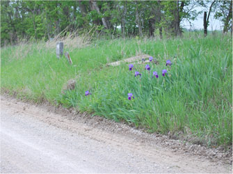
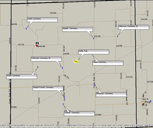
| Location/Directions/Comments | ||||||||
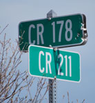 |
Most recent directions | Take 65 Highway north out of Carrollton. Turn west on Z blacktop (toward Coloma) and drive 2.4 miles. Turn south on T blacktop (toward Mandeville) and drive about 2.3 miles (T Hwy will curve several times.) Turn south on CR 211 past CR 178. | ||||||
| original webpage | ||||||||
|
Ancestry.com |
xxxx |
|||||||
|
DAR Index: |
xxx |
|||||||
| LS info | xxx | |||||||
| Other Comments | xxx | |||||||
| Plat Maps | year | marked? | who's land? | |||||
| T/R/S | Original Land Grants | |||||||
| 1877 | yes/no | |||||||
|
1897 |
yes/no | |||||||
| 1914 | yes/no | |||||||
| 1930 | yes/no | |||||||
| 1959 | yes/no | |||||||
| 1970 | yes/no | |||||||
|
1976 |
yes/no | |||||||
| 1997 | yes/no | |||||||
| 2005 | yes/no | |||||||
| Transcriptions online: | ||||||||
| GTT | ||||||||
| Carroll County Archives | ||||||||
| Ancestry.com | ||||||||
| Find-A-Grave | ||||||||
| Other Online Link | ||||||||
| Compilations | xxxx | |||||||
| Library References | ||||||||
| CCGA | Carroll County Cemeteries - volume 1 | |||||||
| Genealogical Library - Ray County Museum | ||||||||
| Ray County Library - Richmond | ||||||||
| Mid-Continent Library | ||||||||
| Family History Library (FHL) | ||||||||
| Lookups | xxxx | |||||||
Carroll County Home Page | MoGenWeb | USGenWeb | WorldGenWeb
To add additional information relating to Carroll County, Missouri Genealogy, E-Mail the county coordinator.
Last Updated