 |  |
| | |
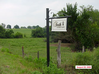
Smith Cemetery | ||||||||
|
| ||||||||
| Name of Cemetery | Smith Cemetery | |||||||
| Township | B2 Leslie Twp | |||||||
| Cemetery # | # | |||||||
| Alternate Names | xxx Cemetery | |||||||
| Latitude/Longitude | Latitude: 39.4814; Longitude: -93.6207 | |||||||
| Township/Range/Section | T54R24S20 | |||||||
| Cemetery Still in Use | Yes | |||||||
| Size of Cemetery | Medium | |||||||
| Condition | Well Maintained | |||||||
| Range of Burial Dates | ||||||||
| Oldest Known Stone: | xxxx | |||||||
| Last Known Burial | xxx | |||||||
| Visited yet? | CC - yes | |||||||
| Location/Directions/Comments | ||||||||
| Most recent directions | From the intersection State Hwy T and State Hwy W, travel north on State Hwy T about 1 mile. "Smith Cemetery" sign is on the east side of the highway and the cemetery on top of the hill is visible from the highway. Turn east on the gravel road and travel about 2/10 mile to the top of the hill. Cemetery is on the south side of the gravel road. | |||||||
| original webpage | ||||||||
| Ancestry.com | xxxx | |||||||
| DAR Index: | xxx | |||||||
| LS info | xxx | |||||||
| Other Comments | xxx | |||||||
| Plat Maps | year | marked? | who's land? | |||||
| T/R/S | Original Land Grants | |||||||
| 1877 | yes/no | |||||||
| 1897 | yes/no | |||||||
| 1914 | yes/no | |||||||
| 1930 | yes/no | |||||||
| 1959 | yes/no | |||||||
| 1970 | yes/no | |||||||
| 1976 | yes/no | |||||||
| 1997 | yes/no | |||||||
| 2005 | yes/no | |||||||
| Transcriptions online: | ||||||||
| GTT | ||||||||
| Carroll County Archives | ||||||||
| Ancestry.com | ||||||||
| Find-A-Grave there are 2 Smith Cemeteries on Find-A-Grave, the second one needs to be deleted, it is a duplicate | ||||||||
| Other Online Link | ||||||||
| Compilations | xxxx | |||||||
| Library References | ||||||||
| CCGA | Carroll County Cemeteries, volume 1 | |||||||
| Genealogical Library - Ray County Museum | ||||||||
| Ray County Library - Richmond | ||||||||
| Mid-Continent Library | ||||||||
| Family History Library (FHL) | ||||||||
| Lookups | xxxx | |||||||
Carroll County Home Page | MoGenWeb | USGenWeb | WorldGenWeb
To add additional information relating to Carroll County, Missouri Genealogy, E-Mail the county coordinator.
Last Updated