 |  |
| | |
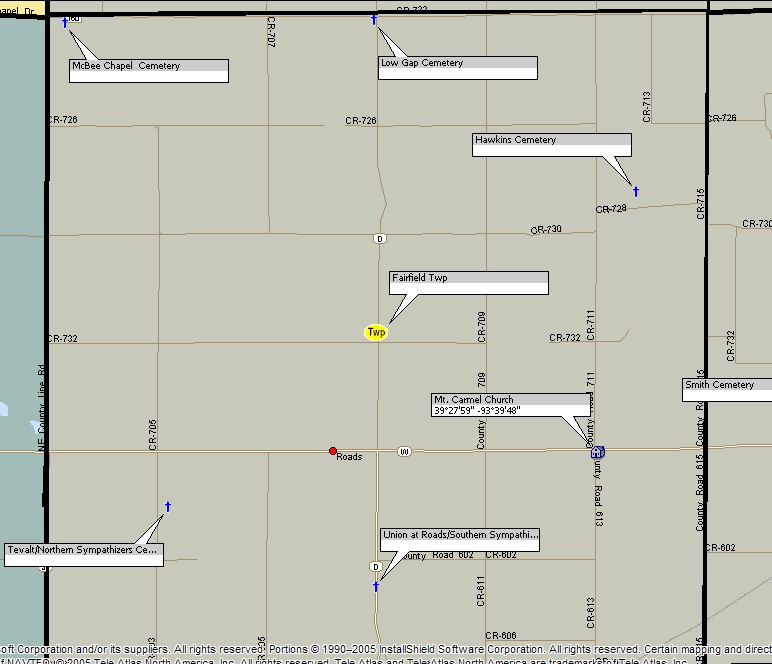
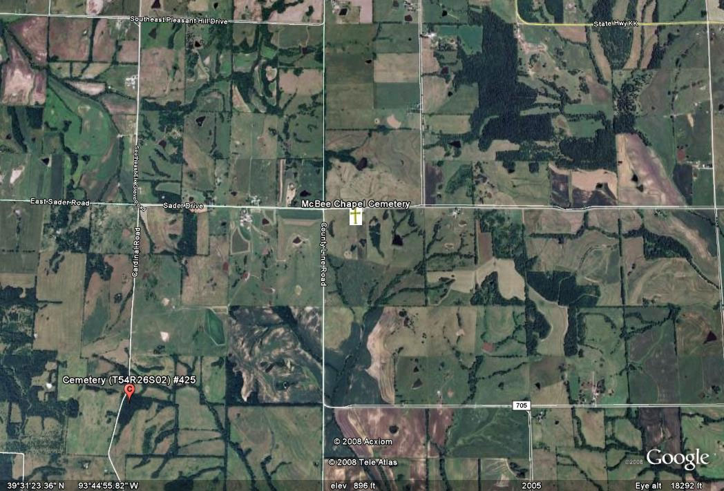
| McBee Chapel Cemetery | ||||||||
 cem photo not available yet |
| |||||||
| Name of Cemetery | McBee Chapel Cemetery | |||||||
| Township | B1 Fairfield Twp | |||||||
| Cemetery # | # | |||||||
| Alternate Names | xxx Cemetery | |||||||
| Latitude/Longitude | Latitude: 39.524N; Longitude: -93.756W | |||||||
| Township/Range/Section | T54R25S06 | |||||||
| Cemetery Still in Use | Yes | |||||||
| Size of Cemetery | xxx | |||||||
| Condition | xxx | |||||||
| Range of Burial Dates | ||||||||
| Oldest Known Stone: | xxxx | |||||||
| Last Known Burial | xxx | |||||||
| Visited yet? | CC - yes/no................ JZ - yes/no...........anyone else - yes/no | |||||||
| Location/Directions/Comments | ||||||||
| Most recent directions | 2/10 mile east of County Line Road on County Road 722 | |||||||
| . | From Carrollton, Missouri, go North on Hwy 65 for 5 miles to Junction W, go West on Route W 13 miles then North on Route D for 4 miles, then West on gravel road for 3 miles. Cemetery is on the South side of the road. It is fenced and maintained. | |||||||
| original webpage | ||||||||
| Ancestry.com | xxxx | |||||||
| DAR Index: | xxx | |||||||
| LS info | xxx | |||||||
| Other Comments | xxx | |||||||
| Plat Maps | year | marked? | who's land? | |||||
| T/R/S | Original Land Grants | |||||||
| 1877 | yes/no | |||||||
| 1897 | yes/no | |||||||
| 1914 | yes/no | |||||||
| 1930 | yes/no | |||||||
| 1959 | yes/no | |||||||
| 1970 | yes/no | |||||||
| 1976 | yes/no | |||||||
| 1997 | yes/no | |||||||
| 2005 | yes/no | |||||||
| Transcriptions online: | ||||||||
| Carroll County Archives | ||||||||
| Ancestry.com | ||||||||
| Find-A-Grave | ||||||||
| McBee Chapel Cemetery Records | ||||||||
| McBee Cemetery Photos For Sale | ||||||||
| Compilations | xxxx | |||||||
| Library References | ||||||||
| CCGA | Cemeteries of Carroll County, volume 1 | |||||||
| Genealogical Library - Ray County Museum | ||||||||
| Ray County Library - Richmond | ||||||||
| Mid-Continent Library | ||||||||
| Family History Library (FHL) | ||||||||
| Lookups | xxxx | |||||||
Carroll County Home Page | MoGenWeb | USGenWeb | WorldGenWeb
To add additional information relating to Carroll County, Missouri Genealogy, E-Mail the county coordinator.
Last Updated