 |  |
| | |
Hill Cemetery | ||||||||
 cem photo not available yet |
| |||||||
| Name of Cemetery | Hill Cemetery | |||||||
| Date Established | ||||||||
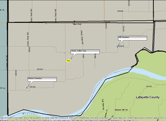
| Township | E1 Cherry Valley Twp | |||||||
| Cemetery # | # | |||||||
| Alternate Names | xxx Cemetery | |||||||
| Latitude/Longitude | Latitude: 39.2497; Longitude: -93.6725 | |||||||
| Township/Range/Section | T/R/S | |||||||
| Cemetery Still in Use | Yes/No | |||||||
| Size of Cemetery | xxx | |||||||
| Condition | The cemetery is in very bad conditon. It is in a clump of trees with a lot of vegitation growth. Several stones are on the ground. There is a sign on the road that states Hill Cemetery. Glen | |||||||
| Range of Burial Dates | ||||||||
| Oldest Known Stone: | xxxx | |||||||
| Last Known Burial | xxx | |||||||
| Visited yet? | CC - yes/no................ JZ - yes/no...........anyone else - yes/no | |||||||
| Location/Directions/Comments | ||||||||
| Most recent directions | Take #10 highway out of Norborne heading south and west. Go to the sharp corner about two miles. Turn east on CR 340. Go east on CR 340 3/4 mi. Turn south on CR 147. Go south on CR 147 1-1/4 mile. Turn back West on CR 350 until it bends back south, you should see sign for Hill Cemetery. It sets back in a field. Glen | |||||||
| original webpage | ||||||||
| Ancestry.com | xxxx | |||||||
| DAR Index: | xxx | |||||||
| LS info | xxx | |||||||
| Other Comments | xxx | |||||||
| Plat Maps | year | marked? | who's land? | |||||
| T/R/S | Original Land Grants | |||||||
| 1877 | yes/no | |||||||
| 1897 | yes/no | |||||||
| 1914 | yes/no | |||||||
| 1930 | yes/no | |||||||
| 1959 | yes/no | |||||||
| 1970 | yes/no | |||||||
| 1976 | yes/no | |||||||
| 1997 | yes/no | |||||||
| 2005 | yes/no | |||||||
| Transcriptions online: | ||||||||
| GTT | ||||||||
| Carroll County Archives | ||||||||
| Ancestry.com | ||||||||
| Find-A-Grave | ||||||||
| Other Online Link | ||||||||
| Compilations | xxxx | |||||||
| Library References | ||||||||
| CCGA | Carroll County Cemetery Records, volume 4 | |||||||
| Genealogical Library - Ray County Museum | ||||||||
| Ray County Library - Richmond | ||||||||
| Mid-Continent Library | ||||||||
| Family History Library (FHL) | ||||||||
| Lookups | xxxx | |||||||
Carroll County Home Page | MoGenWeb | USGenWeb | WorldGenWeb
To add additional information relating to Carroll County, Missouri Genealogy, E-Mail the county coordinator.
Last Updated